The CMTPC Toolbar provides easily memorised button functions:
![]()
|
Menu |
Image |
Description |
|
Select |
|
Clicking this button puts the Mouse Pointer into “Select” mode. Move it over a Map Feature and then click to select it. |
|
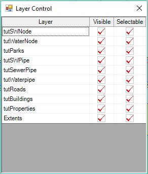
Layer Control |
|
Click this button to open the Layer Control, where you
can make the layers with the
Inspection Map View, Visible / Selectable. |
|
Zoom In |
|
Clicking this button puts the Mouse Pointer into “Magnifier” mode. Move it over a Map Feature and click to “Zoom In” the Map, centred at the Click point. If you have a stylus, you can “Drag” a rectangular shape to define the Zoom. |
|
Zoom Out |
|
Clicking this button puts the Mouse Pointer into “Minifier” mode. Move it over a Map Feature and click to “Zoom Out” the Map, centred at the Click point. |
|
Pan |
|
Clicking this button puts the Mouse Pointer into “Hand” mode. Click and “Drag” it over the Map to pan your view. |
|
Centre |
|
Clicking this button puts the Mouse Pointer into “Centre” mode. Click it on the part of the Map that you want to become the centre. |
|
Info |
|
Clicking this button puts the Mouse Pointer into “Info” mode. Move it over a “Selectable” Map Feature and click to view information related to that feature. |
|
New Inspection |
|
Having selected an Asset on the Map, click this button to open Forms for a new Defect Inspection. |
|
View Previous Inspections |
|
Having selected an Asset on the Map, click this button to open a Form to select and view existing Defect Inspections. |
|
Tag Asset as Inspected |
|
Having selected an Asset on the Map, click this button to record a “Tag” Defect Inspection, where there is no Defect found. |
|
Asset Inspection |
|
Having selected an Asset on the Map, click this option to open a List of available Standard Inspections, to select one and record it on the Asset |
|
Edit Asset Attributes |
|
Having selected an Asset on the Map, click this option to open its Attributes Form, to record a Condition Inspection. |
|
Centre on GPS Location |
|
With the GPS enabled, this button will centre the map on the most recent GPS location received. |
|
Search |
|
Searches for an Asset Map Object by either Asset ID or Asset Description. The Asset Description can be any portion of the entire description; e.g. ‘smith’ will find ’23 Smith Street’. Note: The Asset must be set up in Conquest with either MapMaster or MapRefID value, for Search to work. MapMaster is a flag to indicate that there are one or more other Assets that use its Map Coordinates. On any Asset, MapRefID is the AssetID of a Mapmaster Asset, and can be on one or more Assets. |
|
Enable/Disable GPS |
|
With a GPS set up on the Tablet, it can be enabled by clicking on this option. |
|
GPS Options |
|
Click this button and, from the List turn on/off: •Auto Centering of the GPS location •Display the GPS location as a symbol |
|
Maximise the Inspection Form |
|
Click this button to minimise the Map and maximise the Data section of the screen. |
|
Show the Map Form |
|
Click this button to show both the Map and Data on the screen. |
|
Manage Requests Tool |
|
This button is available, provided that a Requests View has been selected in the CMTPC Administrator Form; otherwise hidden. Click it to open the Manage Requests tool, which immediately refreshes the Requests List for the currently selected Requests View. See Manage Requests for details. |