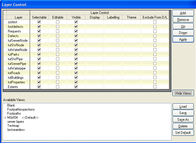
![]() The Layer Control button opens a dialog that, allows the
user to select which map layers to view or to create new Views. A
selection of map layers defines a View. Views can be amended by removing
or adding layers to it. Once the amendments are made, use the Apply button
to activate the changes for the current session. The Save button will make
the changes permanent.
The Layer Control button opens a dialog that, allows the
user to select which map layers to view or to create new Views. A
selection of map layers defines a View. Views can be amended by removing
or adding layers to it. Once the amendments are made, use the Apply button
to activate the changes for the current session. The Save button will make
the changes permanent.
In the “Available View” list, one of the Views can be selected and made the default View by clicking the “Set Default” button. The Default View is the map that is first displayed, when opening Conquest Map.

The Selectable checkbox determines whether an object on that layer can be selected.
The Editable checkbox determines whether an object on that layer can be edited.
The Visible checkbox determines whether a layer is visible on the map.
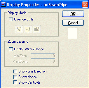
The Display column shows a button that will open the Display screen.

•The Override Style will change the current style on this layer to one selected here.
•The Display within Range check box determines whether the objects of this layer are visible at all times or only at a particular zoom level.
•The Zoom Min determines the minimum zoom ratio this layer’s objects will appear at.
•The Zoom Max determines the maximum zoom ratio this layer’s objects will appear at.
•The Show Line Direction checkbox will show an arrow in the direction that every line was drawn on that layer.
•The Show Centroid checkbox will display the centroid for each object on that layer.
•The Show Nodes checkbox will display the Node points for all objects on that layer.
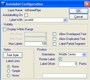
The Labeling function will open this dialog.

•Layer Name displays the name of the current layer.
•The Auto labeling on checkbox determines whether the labels are activated for this layer.
•The Label With drop list is for selecting the underlying map field that is to be used as the label.
•The Display within range checkbox determines whether to display the labels at a specific zoom level or all the time.
•The Min zoom will enable when the Display within range is checked and is used to determine the minimum view ratio at which the Labels are displayed.
•The Max zoom will enable when the Display within range is checked and is used to determine the maximum view ratio at which the Labels are displayed.
•The Max Labels determines the maximum number of labels that can appear at one time for this layer.
•The Allow Overlapped Text checkbox determines whether any labels that overlap will be visible.
•The Allow Duplicated Text checkbox determines whether all similar labels will be visible or just one of them.
•The Label Partial Segment checkbox determines whether the label will appear if there is any portion of a line object visible or not
•The Styles section will determine how the text will be formatted.
•The Position section determines how the label will be orientated to the related object.
The Theme column will open the Thematic Mapping Function
The Exclude from D/L tick boxes are for use with Conquest Mobile for Tablet PC. Conquest Mobile on Tablet PC's is able to download Map Views to use while collecting/inspecting data. This check box allows the administrator to disable the downloading of that particular Layer, of the view, to the Tablet Device. This is most useful for Layers that are large and change rarely (i.e. a Cadastre or Aerial Photo Layer) thereby significantly reducing the download time to the device. This assumes that these layers have been previously downloaded or manually copied to the device or the View will not load correctly on the mobile device.
Buttons on the Control Layer Form
Add Add another layer to the current set of layers in the selected View
Remove Remove a layer from the current set of layers in the selected View
UP, Down Move layers up or down in the current list of layers for the selected View
Apply Apply the amendments to the selected View for this session
Views/Hide Views The Views Button on the Layer control form opens or closes the list of existing Views.
Load Load the list of layers in the current selected View
Save Save any changes made to the list of layers of the selected View
Save As Save the changes as a new View, with the name that you give it
Delete Delete a View (selection of layers)
Set Default Mark a View as the default View. One view should be set to as default and it is this one that is displayed when conquest map is opened.