Structure
This section explains how the Knowledge Base should be structured.
The Knowledge Base contains the information for the Road Segment and Road Surface Types. It also holds the information for the surface treatments to be used in the RSM modelling tool. The surface treatments and associated costs are defined in Planned Standard Actions against each Surface Type. This should reflect the rules established by Council to trigger treatments for preventative resealing, rehabilitation, and reconstruction of the different types of surfaces used in the network.
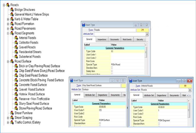
When using RSM alongside Conquest the configuration of the Knowledge Base is done in Conquest. Please see an example of an acceptable structure in Conquest below:
To configure the Asset Type Group ‘Road Segments’ and ‘Road Surface’ please run the sql below in the Query Builder:
Update tblTypes set RSM_Type = 2 where TypeDescription = 'Road Segment' or TypeDescription = 'Road Segment'
Each individual road segment and road surface Asset is then assigned to a Segment Type and a Surface Type.
The example below shows how a possible setup for a Regional Council with sealed and unsealed road surfaces will display in RSM.
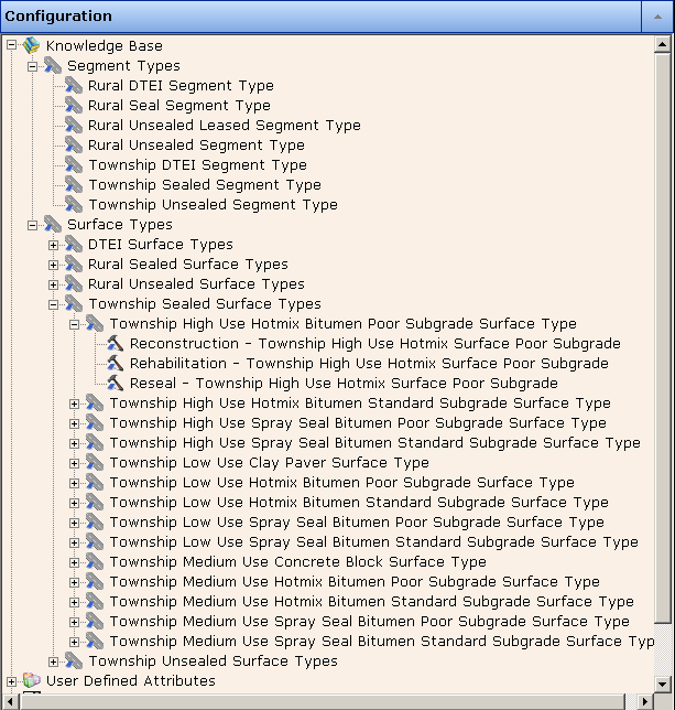
Segment Types
Segment Types contain generic information about the segment. The definition of the information is specified in the User Defined Attributes, described below. The generic information could include:
•Ownership
•Hierarchy
•Traffic Volume
•Pavement type
•Sub grade Type
•Ward or Suburb
•Shape
•Priority Parameters.
Surface Types
Surface Types contain generic information about the pavement surfaces. The definition of the information is specified in the User Defined Attributes, described below. The information could include:
•Length
•Width
•Surface Type
•Condition parameters
•Treatments to be applied.
A minimum configuration of the Knowledge Base requires Segment Types and Surface Types.
Segment Asset Types
Segmentation allows recording of information relevant to various portions of road, such as dates of construction, dates of renewal or replacement, and kinds of material used.
Within the urban road network the segmentation may be from intersection to intersection, or up to 200m. In the rural setting road segments may be defined using the road running distance at 1-2 kilometre intervals. It is considered important to plan network segmentation so that resurfacing work can be programmed to a segment to ensure that over time knowledge and history are maintained. This avoids changing segments every time resurfacing occurs, which then creates a dilemma for capturing history and makes it difficult to track the segment for valuation and condition. Mid-block roundabouts and intersections can be stored in their own segments if it makes sense to do so. This would definitely be necessary if intersections had a unique surface (e.g. pavers) or different deterioration behaviours.
For metropolitan Councils the road network is primarily sealed with Kerb and Gutter and a variety of surfacing treatments. From experience the network deterioration can be influenced by traffic, soil type and surface/pavement type. The combination of these factors can create a complex modelling situation. While RSM can handle this complexity, it is important to make a judgement in setting up the system as to the key drivers in the local area. For instance where industry activity is prominent, traffic loading will be a key consideration to differentiate roads, while in residential areas surface type or soil type may be key factors.
For rural Councils, the road networks tend to be sealed rural roads without Kerb and Gutter, and a majority of unsealed rural roads that are sheeted with rubble. (A small portion of the road network may also be metropolitan in nature.)
Within RSM each road Asset is broken down into segment Assets where segment type data is stored (see examples in the Structure section above) and each segment Asset will have a surface Asset that stores generic information about the surface type.
Here is an example structure of Segment Asset Types to fit the above explanation:
•Metro Council
•Urban Sealed
•Regional Council
•Township Sealed
•Rural Sealed
•Township Unsealed
•Rural Unsealed
Where:
•Urban/Township Sealed Segment – typically roads in the built up areas with kerb and gutter.
•Rural Sealed Segment – typically rural roads where the speed limit exceeds 60km/hr.
•Unsealed Segment – any unsealed township/urban or rural road.
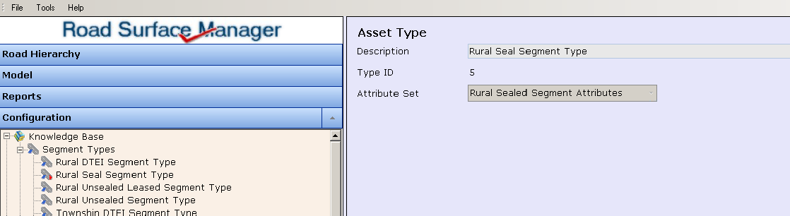
The Road Segment Asset Type form displays the attribute set associated with this Type.
For examples of the typical attributes in an Attribute Set for these segment types see the Structure section.
If RSM 2 is installed alongside Conquest, all the Asset Types and Attribute Sets are created or amended in Conquest.
If RSM 2 is installed as a standalone product, the Asset Types and Attribute Sets are created and amended in RSM 2, in the User Defined Attributes section (see section on User Defined Attributes below).
Surface Asset Types
The setup and configuration of the road surfaces can be as simple or as complicated as necessary to suit the local road environment. As a minimum it is recommended that the user considers a setting of:
•Urban Sealed Surface
•Rural Sealed Surface
•Unsealed Surface
These can be expanded to differentiate between heavily trafficked roads and local roads.
•Rural Sealed – Major
•Rural Sealed – Feeder
•Rural Sealed – Local
The surface type can also be used to allow for difference in deterioration rates.
•Rural Sealed – Hotmix
•Rural Sealed – Sprayseal
•Rural Sealed – Cold Overlay
Alternatively the hierarchy can be a combination of road type and surface type:
•Rural Sealed – Major Hotmix
•Rural Sealed – Major Spray Seal
•Rural Sealed – Major Cold Overlay
•Rural Sealed – Feeder Hotmix
•Rural Sealed – Feeder Spray Seal
•Rural Sealed – Feeder Cold Overlay
In certain Councils highly reactive clay subgrades can provide another variable that can influence the rate of road surface deterioration. This can also be considered along with any other parameters that the road manager believes is important for planning road surface maintenance activities.
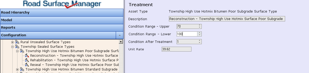
Each Road Surface Asset Type also defines the Attribute Set and Deterioration Curve associated with this surface.
Further to this, each Road Surface Asset Type needs to define the treatment selection to be applied over its lifecycle. For example:
•Preventative treatment
•Rehabilitation treatment
•Reconstruction treatment
Treatment definitions specify the road surface condition at which this particular treatment will be applied, as well as its cost. These treatments are represented in Conquest by Planned Standard Actions.
When RSM 2 is installed alongside Conquest, the treatments can be edited in RSM 2 but must be created in Conquest.
When RSM 2 is a standalone installation, the treatments can be created and deleted as well as edited.
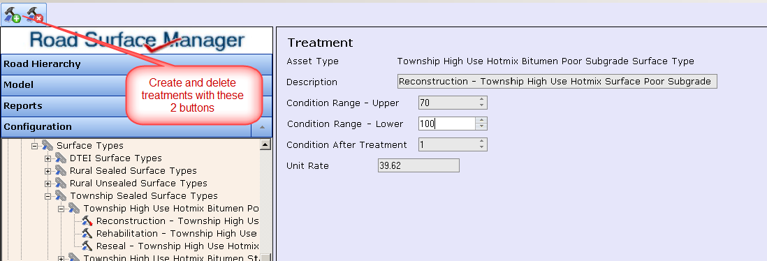
•The Description is a label that reflects the Road Manager’s treatment policy.
•The Condition Range specifies that the treatment should be applied to the road if it falls within that range.
•The Condition after Action specifies the condition rating that the segment improves to after having the treatment.
•The Unit Rate is the unit cost of the treatment. This is used in conjunction with the Dimension to multiply rates by to calculate the cost of applying the treatment to the entire segment.
RSM’s modelling process applies a deterioration to a road segment (according to the deterioration curve selected on the Road Asset Type), and then determines whether the segment’s current condition warrants a treatment. If the segment’s priority ranking merits a share in the available funding, the segment has the treatment applied to it, and the segment’s condition improves to the Condition after Action.